Ops
The working page for the passage: wind and waves at every point on the route, tides, orcas and who to call. The server refreshes the forecast every hour; the page is light, with no photos, so it opens over satellite.
Today on the route
A script works out which day of the plan it is today. Without JavaScript, see the day-by-day plan on the Days page. Day-by-day plan
Wind and waves by point
Each card is a stop or a point under way: current conditions, a 48-hour chart (wind as a line, gusts dashed, waves shaded) and a 7-day summary. Wind and gusts in knots, waves in metres, rain in mm; times are local to each point.
Colour by wind, knots ≤ 12 calm 13–20 fresh 21–30 strong > 30 gale
A script draws the forecast from forecast.json. Without JavaScript it cannot be shown — open Windy or the AEMET bulletin from the links below.
At sea: Ibiza → Cartagena
Cartagena
Cabo de Gata
Almería
La Herradura
Benalmádena / Málaga
La Línea / Gibraltar
Strait off Tarifa
Cádiz
Atlantic, day 1
Atlantic, days 2–3
Atlantic, days 4–5
Approach to Lanzarote
Marina Rubicón
Off Fuerteventura
Puerto de Mogán
Marina San Miguel
Wind along the route
All 18 points in route order, from Ibiza to Tenerife: bar height is the wind now, colour is the gusts, the arrow shows where it blows. Stops are labelled.
Tides
Mediterranean — a 20–30 cm tide, negligible. The Strait and Cádiz — up to 1.2 m at Tarifa and up to 3.5 m at Cádiz: we time the marina entry and the departure on 26.10 by the table. Canaries — 2–2.5 m at springs. The boat draws 1.1 m: marinas and anchorages have plenty of margin, but off the beaches at low water we work out the depth from the chart plus the tide.
A script draws the tide curves from forecast.json (IHM table). Without JavaScript, use the IHM table in the sources.
Playa Blanca — use Arrecife (a few minutes’ difference). Puerto de Mogán — use Pasito Blanco. Marina San Miguel — use Los Cristianos. Gibraltar and Alcaidesa — use Algeciras. Heights are above chart datum.
Windy maps
Live Windy maps: switch the layer inside the window (wind, gusts, waves, swell, currents, rain), move through time with the slider at the bottom. Each map is heavy — over satellite, open one at a time.
The Strait: tidal streams and the window
How the stream runs
In mid-Strait the east-going surface stream starts at high water Tarifa and runs for about 6 hours; then it runs west for ~6 hours. Along the Spanish shore there are inshore counter-currents: a coastal band sets west from roughly an hour after high water until mid-flood. On top of that there’s a constant inflow of Atlantic water, up to 1–2 knots in mid-channel — which is why the west-going phase is weaker than the east-going one.
What we do
On 25.10 we leave Alcaidesa timed to reach Tarifa at the start of the west-going stream (around low water Tarifa), follow the Spanish shore outside the traffic lanes, then head north past Trafalgar to Cádiz — 75 miles, about 12 hours. We set out onto the ocean from Cádiz on 26.10. Tide times are in the table below (Tarifa, Algeciras, Cádiz).
When we don’t go
A Levante (easterly) of 25+ knots against the west-going stream kicks up a short, steep sea — we wait for the window in La Línea, 23–25.10. A Poniente (westerly) of 20+ knots on the nose — we wait too. Ideal: light wind or a gentle Levante from behind, morning, ebb tide.
For reference: the tidal stream atlas is IHM No. 445 “Estrecho de Gibraltar”, referenced to high water Tarifa. The AEMET bulletin for the “Estrecho” zone is in the links.
If orcas approach
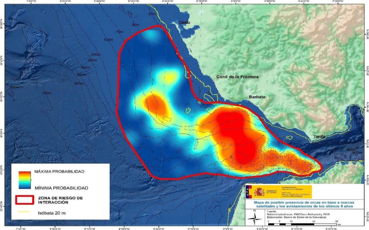
Calmly, and with the facts. Since 2020 the Iberian population — about forty animals — has been taking an interest in the rudders of sailing boats around the Strait and Cádiz. It’s juveniles playing, not hunting: in all these years no person has been hurt, the boats get their rudders repaired. Our Strait crossing on 25.10 is the tail end of their season; in autumn they move out into deep water. The main precaution is already built into the route: the skipper doesn’t head into the ocean from the Strait, he goes north through shallow water along the coast to Cádiz and only from there turns south-west. We still have a plan for an encounter.
Our rules
We don’t sail along the African coast: Sailme forbids it — the boat’s insurance doesn’t apply there, it’s outside EU jurisdiction and the fuel is often questionable.
The orcas stay mostly around Gibraltar. In 15–20 m of water along the Spanish coast the risk is minimal, and we head out into the ocean well north of the Strait — from Cádiz.
What to do
- Before departure — check where they are now The GT Orcas app (GTOA) and the Cruising Association map show encounters over the last few days. If there are recent encounters off Tarifa–Barbate, we stay closer inshore, in water under 20 m where it’s safe to do so.
- Seen close by — stop the boat Drop the sails, engines in neutral, autopilot off. That’s what the official MITECO protocol recommends: they quickly get bored with a boat that doesn’t move.
- Let go of the helm, hands inside Don’t hold the wheel: a blow to the rudder blade is transmitted to your hands. Switch off the echo sounder, keep quiet, don’t lean over the stern, don’t throw anything into the water. Everyone in lifejackets, in the cockpit.
- Call and log it 112 or Salvamento Marítimo on channel 16: report your position and what’s happening. The rescue service will keep track of you and come if needed. Afterwards — a report in the GTOA app: it helps the maps for the next boats.
- They usually leave after 10–40 minutes Afterwards — check both rudders (a catamaran has two, so losing one isn’t critical), the rudder stock seals, and for water in the aft compartments. Then carry on.
In a Cruising Association survey, some skippers motored away at full speed into shallow water instead of stopping and say it helped; the official agencies don’t recommend this. It’s the skipper’s call depending on the situation. Firecrackers, banging on the water and any kind of “deterrents” are banned and don’t work.
MITECO risk map
What else can happen and what to do
To know, not to fear.
Man overboard
The best protection is not falling in: at night and in a seaway everyone is clipped on, and nobody leaves the cockpit alone. If it happens: shout “man overboard”, one person does nothing but watch and point, press MOB on the chartplotter, throw the lifebuoy and horseshoe buoy, turn back towards them, engines in neutral right alongside. Recovery is from the stern platform.
Shipping
The Strait is one of the busiest waterways in the world. We cross the traffic lanes (TSS) only at right angles, never along them, AIS is on and we check every vessel within 3 miles. The rule is simple: a cargo ship has no time to dodge — we dodge.
Weather
We check the forecast twice a day; on the ocean — GRIB files via Starlink or the satellite tracker. We reef early: the rule is “if you’re thinking about a reef, put one in”. Squall — head to wind, ease the sails. Acceleration zones between the Canaries of up to 35 knots are normal, not a surprise.
Nets, pots, fog
Along the Spanish coast and around the Canaries there are octopus-pot buoys and nets. By day the watchkeeper looks ahead; at night we stay more than 2 miles offshore. A line round the prop — knife, mask, and the second engine is still free. Fog does happen in the Strait: radar, AIS, fog signal, slow speed.
Health
Seasickness — a tablet an hour before departure, the horizon, fresh air. Dehydration and sun — water every hour, SPF, shade. The boat’s first-aid kit is shared, your own medication is your own. Radio medical advice — via Salvamento Marítimo (Centro Radio-Médico), on the ocean — via Starlink.
Boat
Leaks — we check the bilges every watch; the pumps are automatic plus a manual one. Fire — gas off after cooking, fire extinguishers by the galley and in the cockpit. Engine failure — there are two. Rudder failure — there are two. Liferaft and EPIRB — know where they are before we leave Gibraltar.
Who to call
- 112 any emergency service — Spain, Gibraltar, the Canaries
- 900 202 202 Salvamento Marítimo (Spanish maritime rescue), 24/7, free
- VHF 16 distress calls and the coastguard; DSC — channel 70, the Distress button
- EPIRB the boat’s emergency beacon: where it is and how to activate it — find out at handover
- Morocco we don’t cross into the 12-mile limit; in distress — the same channel 16 and 112
- Charter base Sailme’s phone number is in the contract and with the skipper; boat breakdowns — call them first
Checklists
Ticks are saved in this browser only.
Sources
- AEMET — marine forecast official bulletins by zone: Alborán, Estrecho, Canarias
- Puertos del Estado — PORTUS real-time buoys: waves, wind, sea level; the iMar app
- IHM — tides source of the tide table above
- Windy ECMWF, GFS, ICON; wave and current layers
- Open-Meteo source of the forecast cards, updated hourly
- GTOA — Grupo de Trabajo Orca Atlántica encounter maps, the GT Orcas app, traffic-light status by zone
- Cruising Association — Orcas map of reports, skippers’ experience, guidance
- MITECO — orca encounter protocol official recommendations and the risk map
- Salvamento Marítimo rescue service, 900 202 202
- MarineTraffic ships around us on AIS — and where we are, for those ashore
- OpenSeaMap nautical chart with buoys and lights; our track was plotted here
- Navily marinas and anchorages with reviews